

This is the land of scenic drives.
Even in a place known for its scenery the terrain surrounding Whiteface Mountain is a standout. From the constantly unfolding mountain vistas to the ways our rocky rivers flow through them, there is an appealing collection of beautiful landscapes and fun stops to enjoy.
Here are our top three picks:
top of the mountain to you
A mountain you can drive up. Now that's a scenic drive.
The Veteran's Memorial Highway is just short of 8 miles long and has an 8% grade. Since its dedication by President Franklin Delano Roosevelt, on Sept. 14, 1935, this definition of mountain road has been delighting visitors of all levels of mobility.
Easy to find, easy to climb, easy for everyone to enjoy — this is our all-access mountain. The highway goes almost all the way to the top, and then an elevator takes people to the peak.

Whiteface is New York state's fifth-highest mountain, at 4,867 feet tall. It is also one of the Adirondack 46ers. (No, driving up and down does not count toward your badge.) On top you'll find incredible vistas, delightful dining at Castle Café, and plenty to browse at the Castle Gift Shop. Find all kinds of outdoor gear, souvenirs, and many Olympic-themed gifts.
The enjoyment starts at the bottom, at the Toll Booth Park, which features an alpine-style gatehouse from 1934. The lovely little pond is named Lake Stevens, after the 1932 Olympian bobsledder Hubert Stevens. It is annually stocked to provide fine fishing, especially for children and visitors with disabilities. Revel in the unique collection of trees, which has 34 species of northern Adirondack natives. Follow the Lake Stevens Tree Trail for a self-guided walk around the pond.

At the top of the mountain, there's a nature trail with a railing. Follow the informational signboards about the special flora and fauna found in our high alpine regions. This "living museum" of forest ecology took a long time to create, on a slowly eroding base of the one-billion-year-old anorthosite bedrock. Fun fact: Anorthosite granite is also found on the moon.

There are plenty of pull-offs on the way up and down, giving eight different outlooks on the present elevation. Enjoy the wildflowers, take pictures, and document the trip.
Pro-tip: on the way back, use a lower gear and engine compression, not your brakes.
Follow the River
For a full day of rugged river landscape, tasty treats, and exploring our antique and craft shops, plan on driving the Ausable River Loop linking the towns of Wilmington, Jay, Upper Jay, and Ausable Forks.

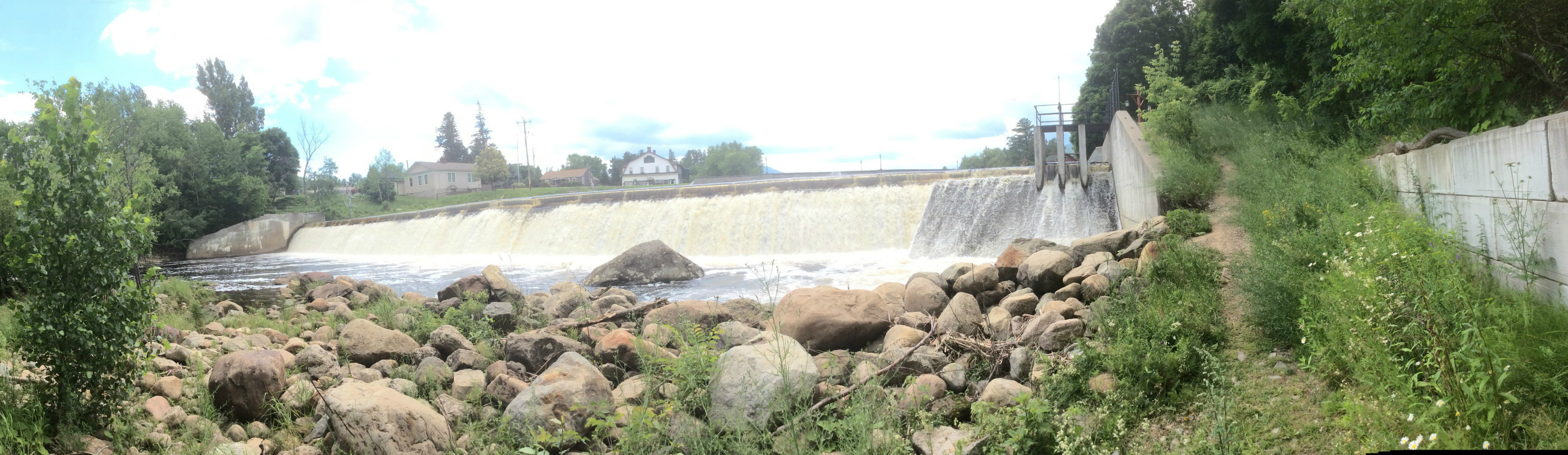
The route carved between the McKenzie Mountain Wilderness and the Sentinel Range Wilderness Area follows the Ausable River all the way to Wilmington. There are lots of places to pull over and walkable fishing access areas to see the river. There's a dam near the center of town, in a park with a little trail (see header photo, above.)
This is the West Branch of the Ausable River, known for its amazing fly fishing, tumbled boulder areas, and shallow rapids. Read our blog, Sweet Treat Tour, for an overview of the goodies in the area. Indulge your artistic side with a stop at Young's Gallery for some gorgeous pottery, woodworking, and fabric items.

Continue on Route 86, east, to the artistic town of Jay, which lies on the East Branch of the Ausable River. This is wider, deeper, and more navigable than the West Branch. You must not miss a visit to the Jay Craft Center, where many local artisans sell their pottery, jewelry, artworks, and much more.
We can head south to Upper Jay, for a stretch of water that turns deep and nourishes thick stands of lush forest. How can Upper Jay be south of Jay? It is because our mountains are so tall our rivers flow down... and sometimes, north.

Or, head north on Route 9N, toward Ausable Forks, where the river widens even more, and one side is open road for abundant sunlight.

There are abundant parks with picnic tables throughout the route, with old single lane bridges, lots of wildflowers, and many interesting big chunks of rock with the river washing over them, changing them ever so slightly every second.
Remember: No one can drive by the same river twice.
Pro-tip: It's only open in the summer, but there are great ice cream, burgers, and shakes at the Whitebrook Dairy Bar, just south of the four-way stop in Wilmington. Bring cash; they don't take debit or credit cards. But there is an ATM a very short walk toward town, over a little bridge and a cute stream.
a rock and a covered place
For a scenic destination, head for a route that includes the Jay Covered Bridge and the famous Jay Rocks. It's called Between the Jays. This is a lovely stretch of the Ausable River with a park along much of it.
The bridge was built in 1851, a classic example of a Howe Truss bridge, with a span of 175 feet. The bridge itself only carries pedestrian and bicycle traffic.

The bridge itself offers many great river views, and also a stunning location; over the river and upstream from the Jay Rocks. This collection of eroded rock looks like someone dropped a bunch of ceramic plates in the river.
While this configuration is not unique to Adirondack rivers, the Jay Rocks is a particularly large and spectacular example. The covered bridge offers wonderful viewing points to see this geographic formation. To enjoy it further, leave the bridge from the opposite end of the little park and follow a hiking path down to the rocks themselves. This popular swimming area appeals to quieter paddling upstream, and body surfing among the tumbled waters.

The action of the river, and especially the sand and pebbles that it carries, will wear away the softer parts first. This creates the waterfalls, slides, and deep pools we see at Jay Rocks.

Pro-tip: Where Route 86 meets Route 9N, take Mill Hill Road, which turns into John Fountain Road. Add more views to the journey by passing Mill Hill Road on the right and take the next right, Route 82, for two more scenic bridges. Now take Mill Hill Road on the right to reach the back entrance to Douglas Memorial Park.
Find out more with our blog post, Jay Rapids - The Adirondacks' Best Kept Secret.
You want to stay close. Find fun dining. Explore all our scenic drives.