About
The Wilmington Peak slide is a popular backcountry ski route, and is sometimes used by experienced bushwhackers and slide climbers to reach the summit of Wilmington Peak. This is not a route for inexperienced slide climbers or skiers.
Getting there
From the main intersection in Wilmington, where Route 86 meets The Whiteface Memorial Highway, continue north on Bonnieview Road. Continue here for 3.2 miles to the state trailhead on the left for Cooper Kiln Pond.
Key takeaways
- Summit elevation: 3458 feet
- Elevation gain: 2,130 feet, round trip (summit and back)
- Distance: 4.9 miles round trip
Rock Climbing
This route requires comfort with slide climbing and exposure. If you have not had prior experience on slides, this route is not the best choice. If you wish to summit Wilmington Peak by other means you can use the Cooper Kiln Pond approach from the south.
Starting from Bonnieview Road in Wilmington the trail begins on a rather flat course along an old road. Once the trail begins to climb it stays fairly steady but not too steep.
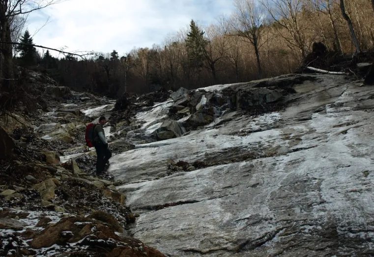
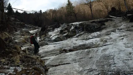
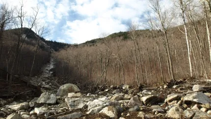
At a height-of-land on a sharp corner you will leave the trail and follow another old woods road for a very short distance to the slide track. This slide came down during Hurricane Irene in 2011 and is still very unstable in areas. This used to be a very small drainage, no more than a couple feet wide, but now it’s 20 feet wide and littered with loose stones and boulders. The footing is very tough along the slide track and at times slippery. As you near the top of the slide, there are some very steep sections where care is needed to safely pass. The headwall is dangerously steep and should be avoided by all but the highly experienced. The headwall can be easily passed to the right.
Once above the slide, the summit is very close and will require some fine-tuned navigation to locate the wooded summit. The forest is relatively open and a flag should be located on the summit tree. To make a loop trip out of the day, use the Cooper Kiln Pond approach to make the return.
Please note
Hikers should have experience in bushwhacking and off-trail navigation. Hikers should be in good physical condition and able to climb steep terrain. Bring a GPS, map, a compass, eye protection, and seasonally appropriate clothing and footwear. Slides are unsafe and should only be attempted by experienced hikers and climbers. Using a rope and harness is always good practice.
Ice climbing and skiing
You will be following a snowmobile trail as well as a state marked foot trail – so watch our for snowmobiles during snow months. Be aware that the trail is designed as a snowmobile trail and gets a bit of use by machines. Expert backcountry skiers do go and do portions of this slide in the winter.


Accessibility Information
Visit Website
Email


Share to:
Additional Info

Packages and Promotions
range
Valid May. 2 - Oct. 25
Valid May. 2 - Oct. 25
High Falls Gorge Online Ticket Sales
High Falls Gorge
High Falls Gorge
High Falls Gorge, the Adirondacks' most stunning 30-minute walk around four waterfalls on the majestic Ausable River, is offering 10% off all summe
promotion
range
Valid Nov. 21 - Dec. 20
Valid Nov. 24 - Dec. 21
Holiday Sale at Young’s Studio and Gallery
Young's Studio & Gallery
Young's Studio & Gallery
Browse the selection of pottery, unique yarn, books, and jewelry, perfect for bringing a piece of the Adirondacks home or gifting to a loved one!
promotion
range
Valid Jan. 29 - Jan. 30
Valid Jan. 28 - Jan. 31
Last Pizza Weekend at The Little Supermarket
This Friday and Saturday mark your final opportunity to enjoy the beloved pizzas and breadsticks from The Little Supermarket.
promotion
range
Valid Nov. 15
Valid Nov. 13 - Nov. 15
$25 Sunday Supper at Summit and Spice
Summit & Spice Restaurant at NewVida Preserve
Summit & Spice Restaurant at NewVida Preserve
Visit Summit and Spice in NewVida Preserve this Sunday, November 16, for the launch of their Blue Plate Special Sunday Dinner.
promotion
range
Valid Apr. 30 - Oct. 30
Valid Apr. 30 - Oct. 30
NY Fiber Trail at Young's Studio & Gallery
Young's Studio & Gallery
Young's Studio & Gallery
Pick up your free passport for the NY Fiber Trail at Young's Studio & Gallery May 1-Oct 31, and discover a wide selection of yarns!
promotion
recurring
Valid
Valid Nov. 20 - Dec. 18
weekly on Friday, Saturday and Sunday until December 21, 2025
Yuletide Family Weekend
Santa's Workshop - Temporarily Closed for Summer & Fall 2026
Santa's Workshop - Temporarily Closed for Summer & Fall 2026
Experience a family Christmas adventure at Santa's Workshop - North Pole, N.Y.! Designed primarily for families with children aged 2 to 10, this package guarantees quality family time with two memorable evenings and two full days of enchantment.
package
Holidays, Activities and Attractions
1
week
FR,SA,SU
FR
range
Valid Dec. 31 - Mar. 31
Valid Dec. 31 - Mar. 31
Ski & Stay at NewVida
NewVida Lodge
NewVida Lodge
Enjoy up to 50% off midweek, non-holiday lift tickets at Whiteface with your NewVida lodge booking for the 2025/26 ski season!*
package
Activities and Attractions, Mid-Week Discounts, Ski
range
Valid Jan. 29 - Jan. 31
Valid Jan. 28 - Feb. 1
Anniversary Giveaway at Small Town Spirits
Small Town Spirits & Wine
Small Town Spirits & Wine
Celebrate with Small Town Spirits all weekend long! Spend $20+ and be entered to win in our basket of cheer!
promotion
range
Valid Feb. 25 - Feb. 28
Valid Feb. 1 - Mar. 1
ADK Winter Pride Specials at NewVida Preserve
NewVida Preserve
NewVida Preserve
Celebrate Adirondack Winter Pride weekend in style at NewVida Preserve! They're turning up the energy with a featured cocktail that’s bold and vibrant: the Pink Pony Club.
promotion
range
Valid Nov. 19 - Dec. 23
Valid Nov. 25 - Dec. 24
Jay Craft Center Annual Sale
Jay Craft Center
Jay Craft Center
Shop Local, Shop ADK! Discover one-of-a-kind, handcrafted gifts right here in the Adirondacks and find the perfect piece of art for your home or someone special.
promotion
recurring
Valid
Valid Dec. 28 - Mar. 30
weekly on Wednesday, Thursday, Friday, Saturday and Sunday until March 31, 2026
Après Ski at NewVida Preserve
NewVida Preserve
NewVida Preserve
Visit NewVida Preserve for Après-Ski at Summit & Spice Wednesday–Sunday from 4:00p.m.-6:00p.m.
promotion
1
week
WE,TH,FR,SA,SU
WE
range
Valid Nov. 22 - Nov. 25
Valid Nov. 19 - Nov. 25
Landscape Paintings Cider Sale!
Landscape Paintings Holiday Cider Sale. Buy 3 or more bottles and save $5/per bottle.
promotion
range
Valid Jan. 4 - Jan. 30
Valid Jan. 4 - Jan. 30
Small Town Spirits January Sale
Small Town Spirits & Wine
Small Town Spirits & Wine
The "New Year, New Sale" event runs throughout January, featuring tiered rewards and deep discounts.
promotion
range
Valid Nov. 25 - Nov. 29
Valid Nov. 10 - Nov. 24
Thanksgiving in the Mountains
Sugar House Retreats
Sugar House Retreats
Spend Thanksgiving at Sugar House ADK Base Camp, a modern farmhouse offering stunning mountain views, a hot tub, and a game room, making it the perfect getaway for family and friends. Enjoy quality time together with various activities and a fully-equipped kitchen to create a memorable holiday feast.
package
Other