About
Hiking New York's 28th tallest mountain
Esther Mountain is the 28th tallest of the Adirondack 46 High Peaks. It is a steep, serious hike that requires significant preparation. A successful hike of Esther involves research, physical fitness, the right gear, and knowledge of Leave No Trace principles. Esther is often climbed with Whiteface Mountain.
Key takeaways
- Distance: 6.3 miles round trip
- Elevation: 4,240 feet
- Elevation gain: 2,750 feet
- Hike includes trail junctions and unmarked trail
- Based on the trail up Marble Mountain from the Atmospheric Science and Research Center (ASRC)
Hiking Esther Mountain
Via the ASRC
This approach is the shortest of the two main options for hiking Esther.
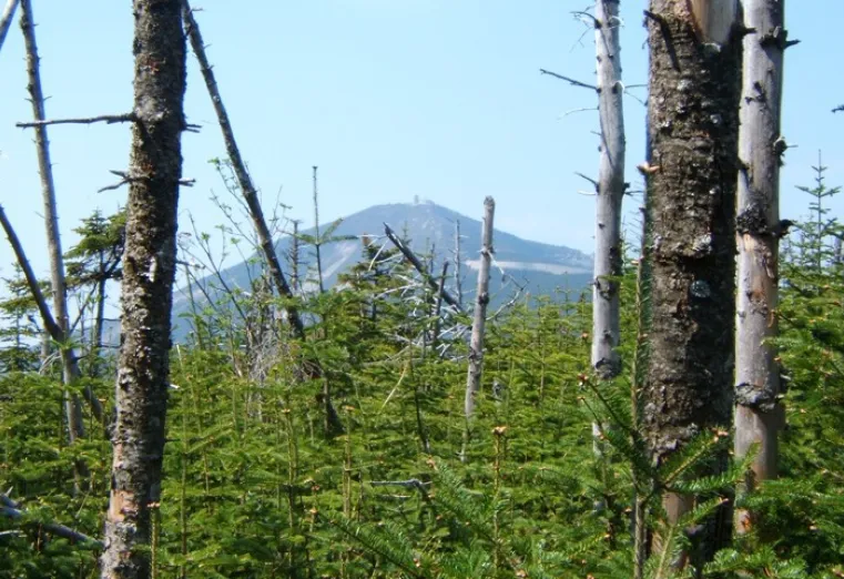
From the trailhead you descend a bit before the start of a steep climb up Marble Mountain. The Marble Mountain section used to be an old ski slope and you will be able to see the old cement footers that still line the trail. This section has loose rock, and when dry in the summer the footing can be quite difficult.
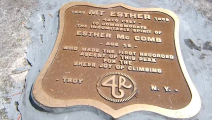
From the top of Marble Mountain you will come to an intersection, left is the secondary trail outlined below. Right is the route you will want. After a short break on a flatter section you will start a demanding climb through a tight evergreen forest that opens up a few views along the way. After about 2.5 miles you will come to a large cairn at a trail intersection. This is the herd path to Esther Mountain, which has no official trail. Making a right onto the herd-path you will climb a bit to the summit of Lookout Mountain where you will have some views to the north. From the summit of Lookout, you will descend for a while to a col between Lookout and Esther. Be sure to not stop at the false summit prior to final push, this can be easy to do when visibility is poor. There is a plaque on the summit in commemoration of Esther McComb, for whom the mountain is named after.
Via the Reservoir
The approach intersects the trail the ASRC; the only difference is it is a bit longer. This route is used as often as the primary trail and offers a slightly easier grade, but more elevation gain.
From the trailhead you will hike through an open forest along a well-trodden foot trail for 1.2 miles. For the most part, the grade isn’t too steep, but it is very steady. It remains steady until the trail then swings right and up steeply to just below the summit of Marble Mountain at the intersection with the primary trail above. Read more on the primary trail above. Taking this way round trip for Esther is 8.6 miles round trip with 3,225 feet of elevation gain.
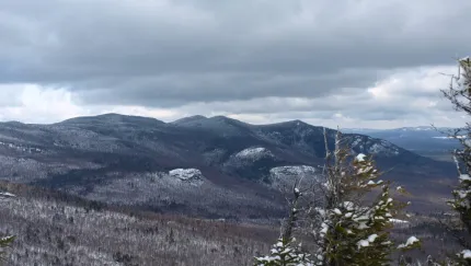
Esther in the winter
Esther is a challenging mountain that should only be attempted by experienced hikers in winter, so make sure you are prepared. Snowshoes are necessary, and microspikes crampons are needed to climb the steeper reaches of the peak. Plan on temperatures in the higher elevations being at least 20 degrees colder than at the trailhead, not including the windchill. Bring several extra non-cotton layers, a headlamp with spare batteries, extra food, a windbreaker, goggles, a face mask, and supplies for spending the night in case of an emergency.
Get close to other trails in the region
Does Esther sound amazing, but a little more than you want to tackle right now? No need to stress, we can help you find a hike that’s right for you!
How to get there
ASRC: From the four-way stop sign in Wilmington, take the turn onto Route 431 (Whiteface Mountain Road) toward the Toll Road. Follow here, go 2.4 miles to the Atmospheric Science Research Center Road on the left. Follow this road around the one-way roundabout to the trail and parking on the right, just past a dirt road that descends into the woods. The trail is not labeled with a DEC sign.
Reservoir: From the four-way stop sign in Wilmington, take the turn onto Route 431 (Whiteface Mountain Road) toward the Toll Road. Go 0.6 miles to Reservoir Road on the left, drive to the end and park
Accessibility Information

Share to:
Additional Info

Packages and Promotions
range
Valid Nov. 22 - Nov. 25
Valid Nov. 19 - Nov. 25
Landscape Paintings Cider Sale!
Landscape Paintings Holiday Cider Sale. Buy 3 or more bottles and save $5/per bottle.
promotion
range
Valid Nov. 19 - Dec. 23
Valid Nov. 25 - Dec. 24
Jay Craft Center Annual Sale
Jay Craft Center
Jay Craft Center
Shop Local, Shop ADK! Discover one-of-a-kind, handcrafted gifts right here in the Adirondacks and find the perfect piece of art for your home or someone special.
promotion
range
Valid Dec. 31 - Mar. 31
Valid Dec. 31 - Mar. 31
Ski & Stay at NewVida
NewVida Lodge
NewVida Lodge
Enjoy up to 50% off midweek, non-holiday lift tickets at Whiteface with your NewVida lodge booking for the 2025/26 ski season!*
package
Activities and Attractions, Mid-Week Discounts, Ski
range
Valid May. 2 - Oct. 25
Valid May. 2 - Oct. 25
High Falls Gorge Online Ticket Sales
High Falls Gorge
High Falls Gorge
High Falls Gorge, the Adirondacks' most stunning 30-minute walk around four waterfalls on the majestic Ausable River, is offering 10% off all summe
promotion
range
Valid Jan. 29 - Jan. 31
Valid Jan. 28 - Feb. 1
Anniversary Giveaway at Small Town Spirits
Small Town Spirits & Wine
Small Town Spirits & Wine
Celebrate with Small Town Spirits all weekend long! Spend $20+ and be entered to win in our basket of cheer!
promotion
range
Valid Nov. 21 - Dec. 20
Valid Nov. 24 - Dec. 21
Holiday Sale at Young’s Studio and Gallery
Young's Studio & Gallery
Young's Studio & Gallery
Browse the selection of pottery, unique yarn, books, and jewelry, perfect for bringing a piece of the Adirondacks home or gifting to a loved one!
promotion
range
Valid Jan. 4 - Jan. 30
Valid Jan. 4 - Jan. 30
Small Town Spirits January Sale
Small Town Spirits & Wine
Small Town Spirits & Wine
The "New Year, New Sale" event runs throughout January, featuring tiered rewards and deep discounts.
promotion
range
Valid Apr. 30 - Oct. 30
Valid Apr. 30 - Oct. 30
NY Fiber Trail at Young's Studio & Gallery
Young's Studio & Gallery
Young's Studio & Gallery
Pick up your free passport for the NY Fiber Trail at Young's Studio & Gallery May 1-Oct 31, and discover a wide selection of yarns!
promotion
range
Valid Feb. 25 - Feb. 28
Valid Feb. 1 - Mar. 1
ADK Winter Pride Specials at NewVida Preserve
NewVida Preserve
NewVida Preserve
Celebrate Adirondack Winter Pride weekend in style at NewVida Preserve! They're turning up the energy with a featured cocktail that’s bold and vibrant: the Pink Pony Club.
promotion
recurring
Valid
Valid Dec. 28 - Mar. 30
weekly on Wednesday, Thursday, Friday, Saturday and Sunday until March 31, 2026
Après Ski at NewVida Preserve
NewVida Preserve
NewVida Preserve
Visit NewVida Preserve for Après-Ski at Summit & Spice Wednesday–Sunday from 4:00p.m.-6:00p.m.
promotion
1
week
WE,TH,FR,SA,SU
WE
range
Valid Nov. 25 - Nov. 29
Valid Nov. 10 - Nov. 24
Thanksgiving in the Mountains
Sugar House Retreats
Sugar House Retreats
Spend Thanksgiving at Sugar House ADK Base Camp, a modern farmhouse offering stunning mountain views, a hot tub, and a game room, making it the perfect getaway for family and friends. Enjoy quality time together with various activities and a fully-equipped kitchen to create a memorable holiday feast.
package
Other
range
Valid Nov. 15
Valid Nov. 13 - Nov. 15
$25 Sunday Supper at Summit and Spice
Summit & Spice Restaurant at NewVida Preserve
Summit & Spice Restaurant at NewVida Preserve
Visit Summit and Spice in NewVida Preserve this Sunday, November 16, for the launch of their Blue Plate Special Sunday Dinner.
promotion
range
Valid Jan. 29 - Jan. 30
Valid Jan. 28 - Jan. 31
Last Pizza Weekend at The Little Supermarket
This Friday and Saturday mark your final opportunity to enjoy the beloved pizzas and breadsticks from The Little Supermarket.
promotion
recurring
Valid
Valid Nov. 20 - Dec. 18
weekly on Friday, Saturday and Sunday until December 21, 2025
Yuletide Family Weekend
Santa's Workshop - Temporarily Closed for Summer & Fall 2026
Santa's Workshop - Temporarily Closed for Summer & Fall 2026
Experience a family Christmas adventure at Santa's Workshop - North Pole, N.Y.! Designed primarily for families with children aged 2 to 10, this package guarantees quality family time with two memorable evenings and two full days of enchantment.
package
Holidays, Activities and Attractions
1
week
FR,SA,SU
FR