
About
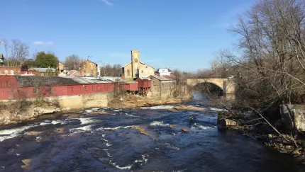
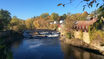
Travel along the Ausable River, over the bridges of Keeseville, and enjoy abundant views of the Adirondack Mountains and river valleys. There is plenty of fine scenery on this loop, which travels from Au Sable Forks to Keeseville, returning on quieter back roads through forest and farmland.
By the numbers
- Distance: 27.3 miles
Cycling
This route has river and mountain views, with some heavier traffic areas with limited shoulders. There are services in Ausable Forks.
Map and turn-by-turn directions on the PDF, and also at the Lake Champlain Bikeways website.

Accessibility Information
Visit Website
Email


Share to:

Packages and Promotions
range
Valid Jan. 29 - Jan. 31
Valid Jan. 28 - Feb. 1
Anniversary Giveaway at Small Town Spirits
Small Town Spirits & Wine
Small Town Spirits & Wine
Celebrate with Small Town Spirits all weekend long! Spend $20+ and be entered to win in our basket of cheer!
promotion
recurring
Valid
Valid Nov. 20 - Dec. 18
weekly on Friday, Saturday and Sunday until December 21, 2025
Yuletide Family Weekend
Santa's Workshop - Temporarily Closed for Summer & Fall 2026
Santa's Workshop - Temporarily Closed for Summer & Fall 2026
Experience a family Christmas adventure at Santa's Workshop - North Pole, N.Y.! Designed primarily for families with children aged 2 to 10, this package guarantees quality family time with two memorable evenings and two full days of enchantment.
package
Holidays, Activities and Attractions
1
week
FR,SA,SU
FR
range
Valid Jan. 4 - Jan. 30
Valid Jan. 4 - Jan. 30
Small Town Spirits January Sale
Small Town Spirits & Wine
Small Town Spirits & Wine
The "New Year, New Sale" event runs throughout January, featuring tiered rewards and deep discounts.
promotion
recurring
Valid
Valid Dec. 28 - Mar. 30
weekly on Wednesday, Thursday, Friday, Saturday and Sunday until March 31, 2026
Après Ski at NewVida Preserve
NewVida Preserve
NewVida Preserve
Visit NewVida Preserve for Après-Ski at Summit & Spice Wednesday–Sunday from 4:00p.m.-6:00p.m.
promotion
1
week
WE,TH,FR,SA,SU
WE
range
Valid Feb. 25 - Feb. 28
Valid Feb. 1 - Mar. 1
ADK Winter Pride Specials at NewVida Preserve
NewVida Preserve
NewVida Preserve
Celebrate Adirondack Winter Pride weekend in style at NewVida Preserve! They're turning up the energy with a featured cocktail that’s bold and vibrant: the Pink Pony Club.
promotion
range
Valid Jan. 29 - Jan. 30
Valid Jan. 28 - Jan. 31
Last Pizza Weekend at The Little Supermarket
This Friday and Saturday mark your final opportunity to enjoy the beloved pizzas and breadsticks from The Little Supermarket.
promotion
range
Valid Nov. 25 - Nov. 29
Valid Nov. 10 - Nov. 24
Thanksgiving in the Mountains
Sugar House Retreats
Sugar House Retreats
Spend Thanksgiving at Sugar House ADK Base Camp, a modern farmhouse offering stunning mountain views, a hot tub, and a game room, making it the perfect getaway for family and friends. Enjoy quality time together with various activities and a fully-equipped kitchen to create a memorable holiday feast.
package
Other
range
Valid Dec. 31 - Mar. 31
Valid Dec. 31 - Mar. 31
Ski & Stay at NewVida
NewVida Lodge
NewVida Lodge
Enjoy up to 50% off midweek, non-holiday lift tickets at Whiteface with your NewVida lodge booking for the 2025/26 ski season!*
package
Activities and Attractions, Mid-Week Discounts, Ski
range
Valid Nov. 21 - Dec. 20
Valid Nov. 24 - Dec. 21
Holiday Sale at Young’s Studio and Gallery
Young's Studio & Gallery
Young's Studio & Gallery
Browse the selection of pottery, unique yarn, books, and jewelry, perfect for bringing a piece of the Adirondacks home or gifting to a loved one!
promotion
range
Valid Nov. 15
Valid Nov. 13 - Nov. 15
$25 Sunday Supper at Summit and Spice
Summit & Spice Restaurant at NewVida Preserve
Summit & Spice Restaurant at NewVida Preserve
Visit Summit and Spice in NewVida Preserve this Sunday, November 16, for the launch of their Blue Plate Special Sunday Dinner.
promotion
range
Valid Apr. 30 - Oct. 30
Valid Apr. 30 - Oct. 30
NY Fiber Trail at Young's Studio & Gallery
Young's Studio & Gallery
Young's Studio & Gallery
Pick up your free passport for the NY Fiber Trail at Young's Studio & Gallery May 1-Oct 31, and discover a wide selection of yarns!
promotion
range
Valid May. 2 - Oct. 25
Valid May. 2 - Oct. 25
High Falls Gorge Online Ticket Sales
High Falls Gorge
High Falls Gorge
High Falls Gorge, the Adirondacks' most stunning 30-minute walk around four waterfalls on the majestic Ausable River, is offering 10% off all summe
promotion
range
Valid Nov. 22 - Nov. 25
Valid Nov. 19 - Nov. 25
Landscape Paintings Cider Sale!
Landscape Paintings Holiday Cider Sale. Buy 3 or more bottles and save $5/per bottle.
promotion