
About
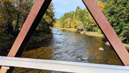
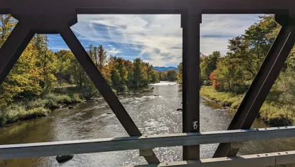
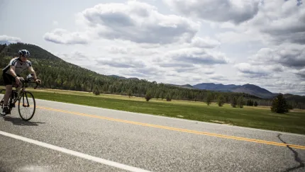
For bridge and river fans! This route follows the river and the farming valleys, with a few challenging ascents that can tire you out quick. No matter how you travel this route, you'll enjoy the scenery.
Distance: 10 mile loop with 650 feet of elevation gain. For a shorter trip, take the Carey Road turn off from 9N.
Directions: Park at the Town of Jay Public Park. and take a right out of the road leading into this lot. Follow until another right on Glen Road, which will lead you across the river with a view of the Jay Covered Bridge. Turn right onto John Fountain Road, picking up Route 9N on the river side, with its gorgeous views and pull-off opportunities. Take the right over the river to Stickney Bridge Road (part is marked as County Highway 9S on some online maps), ascend a steep portion of the road, and bear right past Green Street (staying on Stickney Bridge Road). Online maps have this corner of Stickney Bridge Road marked as North Jay Road. Pass the North Jay Cemetery, and continue on Stickney Bridge Road until you reach the right turn that leads back to the parking lot.
Accessibility Information


Packages and Promotions
range
Valid Jan. 29 - Jan. 31
Valid Jan. 28 - Feb. 1
Anniversary Giveaway at Small Town Spirits
Small Town Spirits & Wine
Small Town Spirits & Wine
Celebrate with Small Town Spirits all weekend long! Spend $20+ and be entered to win in our basket of cheer!
promotion
range
Valid Nov. 19 - Dec. 23
Valid Nov. 25 - Dec. 24
Jay Craft Center Annual Sale
Jay Craft Center
Jay Craft Center
Shop Local, Shop ADK! Discover one-of-a-kind, handcrafted gifts right here in the Adirondacks and find the perfect piece of art for your home or someone special.
promotion
recurring
Valid
Valid Nov. 20 - Dec. 18
weekly on Friday, Saturday and Sunday until December 21, 2025
Yuletide Family Weekend
Santa's Workshop - Temporarily Closed for Summer & Fall 2026
Santa's Workshop - Temporarily Closed for Summer & Fall 2026
Experience a family Christmas adventure at Santa's Workshop - North Pole, N.Y.! Designed primarily for families with children aged 2 to 10, this package guarantees quality family time with two memorable evenings and two full days of enchantment.
package
Holidays, Activities and Attractions
1
week
FR,SA,SU
FR
recurring
Valid
Valid Dec. 28 - Mar. 30
weekly on Wednesday, Thursday, Friday, Saturday and Sunday until March 31, 2026
Après Ski at NewVida Preserve
NewVida Preserve
NewVida Preserve
Visit NewVida Preserve for Après-Ski at Summit & Spice Wednesday–Sunday from 4:00p.m.-6:00p.m.
promotion
1
week
WE,TH,FR,SA,SU
WE
range
Valid Dec. 31 - Mar. 31
Valid Dec. 31 - Mar. 31
Ski & Stay at NewVida
NewVida Lodge
NewVida Lodge
Enjoy up to 50% off midweek, non-holiday lift tickets at Whiteface with your NewVida lodge booking for the 2025/26 ski season!*
package
Activities and Attractions, Mid-Week Discounts, Ski
range
Valid Nov. 22 - Nov. 25
Valid Nov. 19 - Nov. 25
Landscape Paintings Cider Sale!
Landscape Paintings Holiday Cider Sale. Buy 3 or more bottles and save $5/per bottle.
promotion
range
Valid Feb. 25 - Feb. 28
Valid Feb. 1 - Mar. 1
ADK Winter Pride Specials at NewVida Preserve
NewVida Preserve
NewVida Preserve
Celebrate Adirondack Winter Pride weekend in style at NewVida Preserve! They're turning up the energy with a featured cocktail that’s bold and vibrant: the Pink Pony Club.
promotion
range
Valid Jan. 4 - Jan. 30
Valid Jan. 4 - Jan. 30
Small Town Spirits January Sale
Small Town Spirits & Wine
Small Town Spirits & Wine
The "New Year, New Sale" event runs throughout January, featuring tiered rewards and deep discounts.
promotion
range
Valid Nov. 21 - Dec. 20
Valid Nov. 24 - Dec. 21
Holiday Sale at Young’s Studio and Gallery
Young's Studio & Gallery
Young's Studio & Gallery
Browse the selection of pottery, unique yarn, books, and jewelry, perfect for bringing a piece of the Adirondacks home or gifting to a loved one!
promotion
range
Valid Dec. 2 - Dec. 23
Valid Dec. 2 - Dec. 23
Christmas Special in Lake Placid
SHORT-TERM RENTAL PERMIT: STR-200259 Welcome to Cliff View Loj, a stunning Adirondack retreat offering privacy, space, and breathtaking views of Mt
package
Holidays, Mid-Week Discounts
range
Valid Nov. 15
Valid Nov. 13 - Nov. 15
$25 Sunday Supper at Summit and Spice
Summit & Spice Restaurant at NewVida Preserve
Summit & Spice Restaurant at NewVida Preserve
Visit Summit and Spice in NewVida Preserve this Sunday, November 16, for the launch of their Blue Plate Special Sunday Dinner.
promotion
range
Valid Apr. 30 - Oct. 30
Valid Apr. 30 - Oct. 30
NY Fiber Trail at Young's Studio & Gallery
Young's Studio & Gallery
Young's Studio & Gallery
Pick up your free passport for the NY Fiber Trail at Young's Studio & Gallery May 1-Oct 31, and discover a wide selection of yarns!
promotion
range
Valid Jan. 29 - Jan. 30
Valid Jan. 28 - Jan. 31
Last Pizza Weekend at The Little Supermarket
This Friday and Saturday mark your final opportunity to enjoy the beloved pizzas and breadsticks from The Little Supermarket.
promotion
range
Valid May. 2 - Oct. 25
Valid May. 2 - Oct. 25
High Falls Gorge Online Ticket Sales
High Falls Gorge
High Falls Gorge
High Falls Gorge, the Adirondacks' most stunning 30-minute walk around four waterfalls on the majestic Ausable River, is offering 10% off all summe
promotion
range
Valid Nov. 25 - Nov. 29
Valid Nov. 10 - Nov. 24
Thanksgiving in the Mountains
Sugar House Retreats
Sugar House Retreats
Spend Thanksgiving at Sugar House ADK Base Camp, a modern farmhouse offering stunning mountain views, a hot tub, and a game room, making it the perfect getaway for family and friends. Enjoy quality time together with various activities and a fully-equipped kitchen to create a memorable holiday feast.
package
Other